
Keyword
Earth Science | Oceans | Ocean Optics
6 record(s)
Type of resources
Topics
Keywords
Contact for the resource
Provided by
Formats
Update frequencies
Status
draft
-

Results from version 3.1 of the the 4km-resolution biogeochemistry and sediments model of the Great Barrier Reef (GBR4), forced by version2 of the Hydrodynamic model and by a reduced-loads catchment scenario which is derived from SOURCE Catchments with 2019 catchment condition (q3b) with anthropogenic loads (q3b – q3p) reduced according to the percentage reductions of DIN, PN, PP and TSS specified in the Reef 2050 Water Quality Improvement Plan (WQIP) 2017-2022 as calculated in Brodie et al., (2017). Further, the reductions are adjusted to account for the cumulative reductions already achieved between 2014 and 2019 that will be reflected in the 2019 catchment condition used in q3b. This model configuration and associated results dataset may be referred to as "GBR4_H2p0_B3p1_Cq3R_Dhnd" according to the eReefs biogeochemical simulation naming protocol. The model ran in hindcast-mode as one of a suite of simulations which included baseline (GBR4_H2p0_B3p1_Cq3b_Dhnd) and pre-industrial (GBR4_H2p0_B3p1_Cq3p_Dhnd) catchment scenarios.
-

Results from version 3.1 of the 4km-resolution regional-scale biogeochemistry and sediments model of the Great Barrier Reef (GBR4), forced by version 2.0 of the 4km-resolution hydrodynamic model and with Furnas relationships for wet and dry tropics rivers as catchment inputs. This model configuration and associated results dataset may be referred to as "GBR4_H2p0_B3p1_Cfur_Dnrt" according to the eReefs biogeochemical simulation naming protocol. The model runs in near-real-time mode, updating daily.
-
Results from version 3.1 of the 4km-resolution regional-scale biogeochemistry and sediments model of the Great Barrier Reef (GBR), forced by version 2.0 of the 4km-resolution hydrodynamic model and with catchment forcing from P2R SOURCE Catchments with pre-industrial catchment condition from December 01, 2018 to June 30, 2018 and then Empirical SOURCE Catchments with pre-industrial catchment condition from July 1, 2018 to April 30, 2019. This model configuration and associated results dataset may be referred to as "GBR4_H2p0_B3p1_Cq3p_Dhnd" according to the eReefs biogeochemical simulation naming protocol. The model ran in hindcast-mode as one of a suite of simulations which included baseline (GBR4_H2p0_B3p1_Cq3b_Dhnd) and reduced-load (GBR4_H2p0_B3p1_Cq3R_Dhnd) catchment scenarios.
-

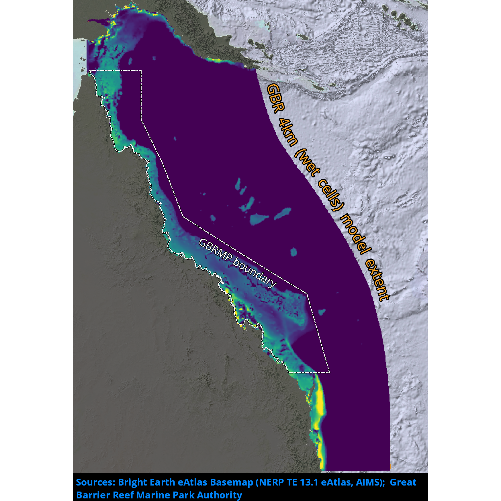
Results from version 3.1 of the 4km-resolution biogeochemistry and sediments model of the Great Barrier Reef (GBR4), forced by version 2.0 of the 4km-resolution hydrodynamic model and by a baseline catchment scenario which is derived from P2R SOURCE Catchments with 2019 catchment condition from December 1, 2010 to June 30, 2018 and from empirical SOURCE Catchments with 2019 catchment condition from July 1, 2018 to April 30, 2019. This model configuration and associated results dataset may be referred to as "GBR4_H2p0_B3p1_Cq3b_Dhnd" according to the eReefs biogeochemical simulation naming protocol. The model ran in hindcast-mode as one of a suite of simulations which included pre-industrial (GBR4_H2p0_B3p1_Cq3p_Dhnd) and reduced-load (GBR4_H2p0_B3p1_Cq3R_Dhnd) catchment scenarios.
-
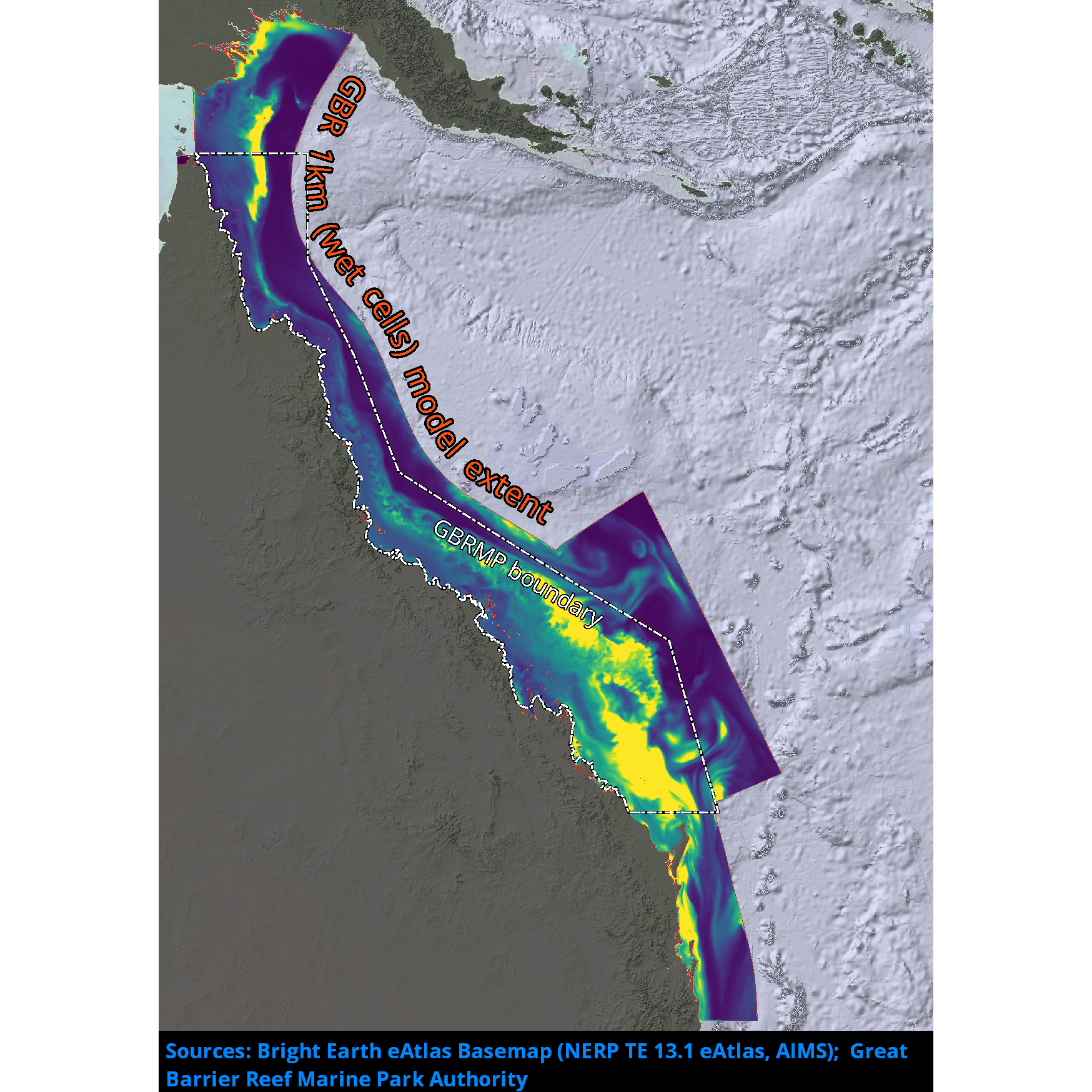
Results from version 3.2 of the 1km-resolution regional-scale biogeochemistry and sediments model of the Great Barrier Reef (GBR1), forced by version 2.0 of the 1km-resolution hydrodynamic model and with Furnas relationships for wet and dry tropics rivers as catchment inputs. This model configuration and associated results dataset may be referred to as "GBR1_H2p0_B3p2_Cfur_Dnrt" according to the eReefs biogeochemical simulation naming protocol. The model runs in near-real-time mode, updating daily.
-
This record describes the Conductivity-Temperature-Depth (CTD) data collected from the Marine National Facility RV Investigator Voyage IN2017_V05, titled: Long-term recovery of trawled marine communities 25 years after the world’s largest adaptive management experiment. The voyage took place between October 11 and November 10, 2017 departing from Broome (WA) and arriving in Fremantle (WA). Data for 72 deployments were acquired using the Seabird SBE911 CTD unit 23, fitted with 36 twelve litre bottles on the rosette sampler. Sea-Bird-supplied calibration factors were used to compute the pressures and preliminary conductivity values. CSIRO -supplied calibrations were applied to the temperature data. The data were subjected to automated QC to remove spikes and out -of-range values. The final conductivity calibration was based on a single deployment grouping. The final calibration from the primary sensor had a standard deviation (S.D) of 0.0012983 PSU, within our target of 'better than 0.002 PSU'. The standard product of 1dbar binned averaged were produced using data from the primary sensors. The dissolved oxygen data calibration fit had a S.D. of 0.6416µM. The agreement between the CTD and bottle data was good. The Biospherical photosynthetically active radiation (PAR), C-Star transmissometer, Aqua tracker Flurometer, ISUS Nitrate sensors were also installed on the auxiliary A/D channels of the CTD. Along with a Wetlabs Eco-triplet and a particle size analyser.